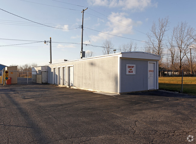
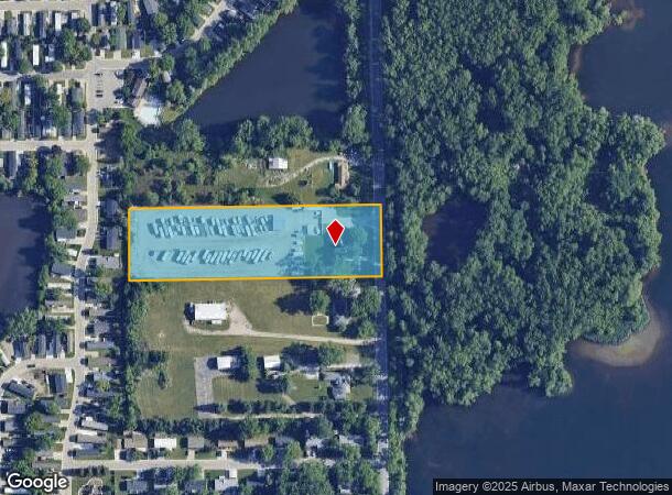
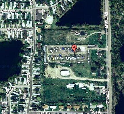
Property Record
6300 Bunton Rd, Ypsilanti, MI 48197
NEARBY LISTINGS FOR SALE OR LEASE
Property Detail
6300 Bunton Rd
11-26-100-007
YP#26-2B COM AT E 1/4 POST OF SEC, TH N 986.31 FT IN E LINE OF SEC FOR A PL OF BEG, TH N 89DEG 42' 34 W 662.59 FT
Commercialnec
Washtenaw
X
Michigan
26161C0430E
2.85 AC
0
Washtenaw E of 23
2025
Detroit
413200
Ann Arbor, MI
1,716 SF
DEMOGRAPHICS near 6300 Bunton Rd
1 Mile
3 Mile
5 Mile
2024 Total Population
4,740
39,208
94,584
2029 Population
4,741
38,640
93,350
Pop Growth 2024-2029
+ 0.02%
(1.45%)
(1.30%)
Average Age
37
39
38
2024 Total Households
1,964
15,966
39,247
HH Growth 2024-2029
(0.15%)
(1.59%)
(1.47%)
Median Household Inc
$72,324
$71,779
$57,808
Avg Household Size
2.40
2.40
2.30
2024 Avg HH Vehicles
2.00
2.00
2.00
Median Home Value
$159,183
$197,771
$192,087
Median Year Built
1998
1978
1974
Nearby Places
Map Layers
Map Styles
 Street
 Aerial
- Restaurants
- Banks
- Shops
- Fitness
- Groceries
PUBLIC TRANSPORTATION
AIRPORT
Detroit Metro Wayne County
DRIVE
WALK
Distance
Detroit Metro Wayne County
21 min
14.6 mi
Freight Ports
Port of Toledo
DRIVE
WALK
Distance
Port of Toledo
71 min
56.3 mi
Nearby Properties
Address
Land Use
TOTAL SIZE
Lot Size
Zoning
Address
Land Use
TOTAL SIZE
Lot Size
Zoning
277.73 AC
Address
Land Use
TOTAL SIZE
Lot Size
Zoning
38,001 SF
177.04 AC
BA
Address
Land Use
TOTAL SIZE
Lot Size
Zoning
11,847 SF
91.35 AC
II
Address
Land Use
TOTAL SIZE
Lot Size
Zoning
97.69 AC
Address
Land Use
TOTAL SIZE
Lot Size
Zoning
19,692 SF
21.22 AC
BA
Address
Land Use
TOTAL SIZE
Lot Size
Zoning
206,958 SF
8.33 AC
AP
Address
Land Use
TOTAL SIZE
Lot Size
Zoning
198,549 SF
13.43 AC
RM MULT
Address
Land Use
TOTAL SIZE
Lot Size
Zoning
196,044 SF
18.67 AC
RM MULT
Address
Land Use
TOTAL SIZE
Lot Size
Zoning
12,747 SF
17.90 AC
BA
Address
Land Use
TOTAL SIZE
Lot Size
Zoning
1,960 SF
59.97 AC
Address
Land Use
TOTAL SIZE
Lot Size
Zoning
889,111 SF
78.78 AC
Address
Land Use
TOTAL SIZE
Lot Size
Zoning
19,008 SF
9.68 AC
Address
Land Use
TOTAL SIZE
Lot Size
Zoning
4,636 SF
18.91 AC
Address
Land Use
TOTAL SIZE
Lot Size
Zoning
161,042 SF
26.29 AC
II
Address
Land Use
TOTAL SIZE
Lot Size
Zoning
12,747 SF
7.37 AC
BA
Address
Land Use
TOTAL SIZE
Lot Size
Zoning
126,711 SF
12.74 AC
Address
Land Use
TOTAL SIZE
Lot Size
Zoning
12,316 SF
5.51 AC
BA
Address
Land Use
TOTAL SIZE
Lot Size
Zoning
29,610 SF
9.10 AC
BA
Address
Land Use
TOTAL SIZE
Lot Size
Zoning
12,747 SF
6.25 AC
BA
Address
Land Use
TOTAL SIZE
Lot Size
Zoning
134,499 SF
6.20 AC
BA
Address
Land Use
TOTAL SIZE
Lot Size
Zoning
1,744 SF
41.75 AC
BI
Address
Land Use
TOTAL SIZE
Lot Size
Zoning
72,834 SF
4.97 AC
RM MULT
Address
Land Use
TOTAL SIZE
Lot Size
Zoning
1,680 SF
20 AC
II
Address
Land Use
TOTAL SIZE
Lot Size
Zoning
73,239 SF
6.18 AC
RM MULT
Address
Land Use
TOTAL SIZE
Lot Size
Zoning
66,340 SF
6.59 AC
RM MULT
Address
Land Use
TOTAL SIZE
Lot Size
Zoning
54.32 AC
RMH MOB
Address
Land Use
TOTAL SIZE
Lot Size
Zoning
3,456 SF
7.77 AC
BA
Address
Land Use
TOTAL SIZE
Lot Size
Zoning
89,778 SF
9.65 AC
C1 GEN
Address
Land Use
TOTAL SIZE
Lot Size
Zoning
51,840 SF
9.07 AC
Address
Land Use
TOTAL SIZE
Lot Size
Zoning
16,414 SF
7.66 AC
BA
The World's #1 Commercial Real Estate Marketplace
Connect with us
© 2025 CoStar Group
The information above has been obtained from sources believed reliable. While we do not doubt its accuracy we have not verified it and make no guarantee, warranty or representation about it. It is your responsibility to independently confirm its accuracy and completeness. Any projections, opinions, assumptions, or estimates used are for example only and do not represent the current or future performance of the property. The value of this transaction to you depends on tax and other factors which should be evaluated by your tax, financial, and legal advisors. You and your advisors should conduct a careful, independent investigation of the property to determine to your satisfaction the suitability of the property for your needs.